
QuickStart Maturity™ Studies and Services
Dolan Integration Group offers multiple options to help evaluate your current and future properties in the Energy Sector. DIG has used petroleum systems models for decades to help our clients succeed. We created the QuickStart Maturity™ Models to assist geologists and engineers with understanding heat distribution in the subsurface by modeling depositional and subsidence history. These 4D models have multiple applications in the exploration, development, production, and environmental aspects of hydrocarbon distribution. The QuickStart Maturity Studies can help assess fluid quality and can be predictive regarding the presence of oil, gas condensate, or gas fluids as well as changes over time of these fluids due to subsidence variability in sedimentary basins.
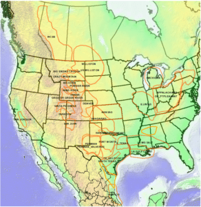
Dolan Integration Group has constructed regional maturity models for most of the major petroleum basins in the onshore U.S. lower 48. In addition, we have modeled basins in Canada, Mexico, Australia, South America, and Asia. These QuickStart Maturity Models are useful for high grading proven and emerging conventional and unconventional plays. Multiple horizons per basin have modeled (predicted) maturity which is critical to the evaluation of potential acquisitions and divestments. For unconventional plays, these models have proven to be accurate over several years in identifying areas which are prospective for oil, wet gas, and dry gas. Some basins have been updated multiple times as new rock maturity and other drilling data becomes available.
QuickStart Maturity Models are also used to support more detailed subregional and local geochemical studies. Uses of the QuickStart Maturity Studies can be seen in the following video featuring the Powder River and Denver Basins.
DIG strives to accomplish three goals:
- Formulate cost effective geochemical evaluations by working closely with the client.
- Technical excellence in a timely manner.
- Be responsive to our clients’ needs.
These studies support our clients’ goal of assessing petroleum potential for the entire sedimentary section. Structural horizons, rock maturity and temperature gradient data is input to produce a calibrated basin wide maturity model. QuickStart Maturity Studies require the following inputs:
- Regional structural surfaces
- Tertiary erosion map
- Temperature gradient from bottom hole temperatures map
- Rock maturity data (primarily vitrinite reflectance and pyrolysis)
- Temperature gradient calibrated to rock maturity
These studies provide an interpretation of several important features of unconventional plays. DIG QuickStart studies include the following outputs:
- Regional structural surfaces
- Tertiary erosion map
- Calibrated temperature gradient map used for modeling
- Raw rock maturity data (vitrinite reflectance and pyrolysis)
- Vitrinite reflectance averaged by well and formation (edited for quality control)
- Vitrinite reflectance equivalence (VRE) from pyrolysis (Tmax) averaged by well and formation (edited for quality control)
- TOC Data
- Measured TOC and original TOC maps (selected horizons)
- Gross and net source isopach maps (selected horizons)
- Predicted GOR and condensate yield maps (selected horizons)
- Present day formation temperature maps (selected horizons)


| Basin | Calculated Maturity Surface in Vitrinite Reflectance Equivalence (VRE) | Structural Surfaces | Vitrinite Reflectance Data | Pyrolysis Data | TOC Data | Bottom Hole Temperature Measurements | 1D Models with VRE vs Depth and Burial History Plots |
| Anadarko Basin | 21 | 21 | 887 | 340 | 324 | 51600 | |
| Appalachian Basin | 21 | 21 | 851 | 2964 | 2379 | 1466 | 166 |
| Arkoma Basin (Oklahoma) | 10 | 10 | 58 | 183 | |||
| Big Horn Basin | 14 | 13 | 41 | 1088 | 980 | 342 | |
| Big Snowy Basin | 6 | 6 | 14 | 161 | 161 | 158 | |
| Crazy Mountain Basin | 15 | 15 | 140 | 16 | 22 | 195 | 14 |
| Denver (DJ) Basin | 15 | 15 | 2324 | 5102 | 6679 | 30600 | 11 |
| Eagle Ford Basin | 13 | 13 | 116 | 133 | 133 | 2847 | |
| East Texas Basin | 8 | 8 | 49 | 17 | 17 | 1433 | |
| Fort Worth Basin | 7 | 7 | 27 | 17 | 780 | ||
| Greater Green River Basin | 16 | 16 | 784 | 3487 | 4145 | 1902 | |
| Hanna Basin | 8 | 8 | 43 | 292 | 292 | 58 | |
| Illinois Basin | 7 | 7 | 934 | 262 | 972 | ||
| Kansas | 14 | 14 | 97 | 926 | 1185 | 67200 | |
| Louisiana – Gulf Coast | 6 | 6 | 2188 | ||||
| Louisiana – Mississippi Salt Basin | 7 | 7 | 287 | 1185 | 1439 | 2509 | |
| Michigan Basin | 8 | 8 | 37 | 67 | 67 | 1464 | |
| Paradox Basin | 9 | 9 | 125 | 1561 | 1726 | 281 | |
| Permian Basin | 20 | 20 | 1474 | 300 | 300 | 2006 | 79 |
| Piceance Basin | 5 | 5 | 202 | 1389 | 1389 | 9883 | |
| Powder River Basin | 12 | 12 | 304 | 5652 | 6007 | 3836 | 10 |
| San Joaquin Basin | 5 | 5 | 339 | 1421 | 1915 | 298 | |
| San Juan Basin | 14 | 14 | 1955 | 1315 | 1315 | 468 | 5 |
| Tampico Basin (Mexico) | 15 | 15 | 71 | 28 | 223 | ||
| Texas Gulf Coast Basin | 8 | 8 | 183 | 257 | 266 | 2847 | |
| Uinta Basin | 6 | 6 | 59 | 917 | 959 | 205 | |
| Western Canadian Sedimentary Basin (WCSB) | 14 | 14 | 646 | 8674 | 8674 | 4080 | |
| Wind River Basin | 11 | 11 | 584 | 849 | 938 | 223 | |
| Williston Basin (US) | 16 | 16 | 378 | 3869 | 4194 | 2698 | |
| Williston Basin (US/Canada) | 10 | 10 | 448 | 12158 | 12483 | 942 |